Showing posts with label Wisconsin. Show all posts

Sunday, August 21, 2011

Lake Itasca :: Headwaters of the Mississippi

Monday, August 8th - - About 9:15 pm a Park Ranger drove through the campground at Copper Falls announcing over the loudspeaker that the National Weather Service had issued a severe storm warning effective until ten o'clock. High winds, hail, heavy rain and lightening were imminent. All campers were to take immediate shelter!

I saw people scurrying around their tents putting things away and heading towards their cars or trucks. Me? I was already sitting in Van Dora. Snug as a bug in a rug. I didn't see anyone leaving the area so I stayed put. Besides, where were we to go?

Within a few minutes after making the announcement, the rain came. Aside from a lot of lightening there was only the rain. No hail. No high winds. And it only lasted about an hour. And for that I was thankful. My thoughts went to that campground in Arkansas last year where flash floods went through the area and several people lost their lives. We had some warning, and I was ready to leave, if necessary. But the question came once again, where would we go?

Tuesday, August 9th - - It was cloudy and overcast this morning. It rained off and on all morning. I was traveling west on US 2 toward Minnesota. At Ashland, Wisconsin I picked up State Road 13 and followed it along the beautiful Lake Superior shoreline all the way to Superior-Duluth where I returned to US 2. By then the weather had cleared. The clouds were gone (mostly) and sunshine filled the skies as I traveled nearly three-fourths of the way across Minnesota. I would spend several days at Itasca State Park south of Bemidji.

Wednesday, August 10th - - Itasca is a huge State Park with a lodge, cabins, two campgrounds with more than 250 sites, more than 40 miles of hiking trails, a 5.8 mile paved biking trail, and numerous lakes within its 32,000 acres. The Park was established in 1891 to preserve remnant stands of virgin pine and to protect the basin around the source of the Mississippi River.


This little stream doesn't look like much, does it? However, it is the Mississippi River, flowing rather quickly just a few hundred feet from its source at the north end of Lake Itasca.


This sign proclaims “Here 1475 ft above the ocean the mighty Mississippi begins to flow on its winding way 2552 miles to the Gulf of Mexico.” My Mother and I visited New Orleans in the summer of 2003 and saw where the Mississippi flowed into the delta and into the Gulf. Like US Highway 41, I've traveled along portions of the Mississippi and now I've not only been at its end, I've seen its beginning. Rather cool, I think.


This is it. The headwaters of the Mississippi River. People are encouraged to “walk across the Mississippi” here, one of the few places accessible for the average person to do so.


The rocks were quite slippery. This man and his son nearly toppled into the water several times. I didn't attempt to walk across the rocks but there was a narrow log footbridge - perhaps 18 inches wide, so maybe not so narrow, but it seemed so when walking across it without handrails for assistance!

I walked a ways down the trail along the shore of the lake but little could be seen because of the trees. There were some interesting wild flowers though!


And this small, fluffy, milkweed type of plant.

Saturday, August 20, 2011

The Copper Falls Trail

Monday, August 8th - - For some reason, I was quite ambitious today and went on a second hike. This was a 1.7 mile loop through the forest, along the river, with a few stair-steps involved as well as some other downhill/uphill sections where there were some handrails to help provide support. I'm not ashamed to admit that I made ample use of the handrails!

The trail would also cross two rivers in three places on very sturdy foot bridges and we'd see several waterfalls along the way. The pictures I took really do not do it justice. To fully appreciate the area you have to be there – feel the spray from the water and hear the roar of the river as it drops over the ledges and through the narrow passageways that it has carved out over many years. This was one hike that was definitely worth the effort!


A small portion of Copper Falls, which drops about 12 feet, on the Mad River. Like the Tahquamenon Falls, the copper color comes from tannin in the water.


A slightly better angle, but still showing only a small part of the falls.


This view shows it a little better – how the river has carved two paths around and through the stone walls of the canyon - but I think the only way you could get a really good shot of this falls would be by being suspended over the river in front of the falls, with a wide angle lens on the camera!

Flowing in a northeasterly direction, the Mad River essentially “runs into” a stone wall, making an abrupt left turn to the west. Coming in from the east is Tyler Forks. Visualize a rather crooked “T” with Mad River being the long upright part as well as the left hand part. Tyler Forks would be the right hand side of the “T” with a bit of a zig and zag just before and after it meets up with the Mad River.


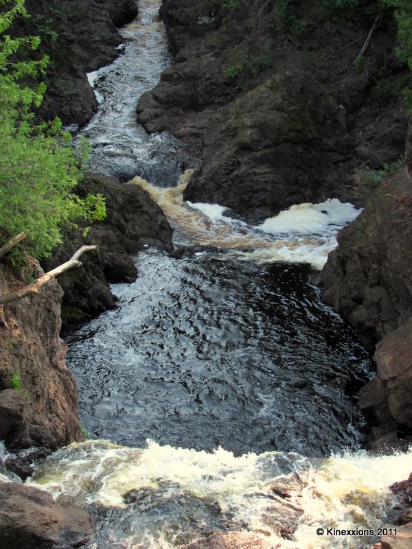
Brownstone Falls is created when Tyler Forks plunges down 30 feet to join the Mad River. The name Brownstone comes from the color of the rocks surrounding it. They were formed eons ago from lava flows that contained small quantities of iron. Tyler Forks curves off to the right, eastward, above Brownstone Falls.


This picture provides no perspective whatsoever! But, there is the Mad River coming in at the top of the picture. The “whitewater” at the bottom of the image is actually Brownstone Falls dropping over the edge of a 30 foot cliff, plunging down and meeting up with the Mad River. Together they continue their journey as Mad River, veering off to the right (where the white foam is in the center of the photo). The sound was incredible. Not nearly as loud as Niagara Falls by any means or even Upper Tahquamenon Falls, but the sound reverberated around the canyon.


Okay, maybe this is a little better. But it still appears as though the water is flowing in from the right and the bottom and going out the top. You'll have to trust me, it isn't.


Adding to the sound of falling water was Tyler Cascades, which is a set of four smaller waterfalls just above and to the east of Brownstone Falls. Simply Gorgeous!

The trail followed Tyler Forks to the east a little ways then crossed at a point just above the cascades. By then the roar of Brownstone Falls was muted and the sound of the water tumbling over the rocks was quite soothing.

Oh, yes! This was one hike that was definitely worth the effort! And I savored every minute of it...

Friday, August 19, 2011

Sometimes It Doesn't Seem Like it's Worth the Effort

But you'll never know unless you try!

Monday, August 8th - - After leaving the Keweenaw Peninsula, I headed south (really, the only direction I could go from there!) and, after a few hours, entered Wisconsin. My sojourn in Pure Michigan had come to an end. A beautiful place, but honestly, I was tired of the humidity - I was hot and sticky during the day and cold and clammy at night! Some place with a little less humidity was in my forecast.

My stay in Wisconsin would be brief – one night and parts of two days traveling across the uppermost tip and along the shoreline of Lake Superior. A quick check of the map and I saw that Copper Falls State Park was just a few miles across the Wisconsin state line, southwest of the town of Ironwood. I arrived at Copper Falls early in the afternoon and secured a very nice campsite.

I had gotten some information about trails when I checked in and the lady at the desk told me about two popular hikes. One of the hikes was to an observation tower. Now, she didn't explicitly state that there was a nice view but it was somewhat implied. You know, it's an observation tower so there “has” to be a good view. She did state that there was a flight of stairs with a few steps involved along the trail as well as at the tower itself. My knees do much better on the way up stairs than they do on the way down, but, I thought I could handle what she described. After a short walk along a relatively smooth trail, uphill, I came to this:


It didn't look so bad. Wide steps and each one wasn't very high. Onward I went. This is the view looking down from the top.


And this is what awaited around the bend...


At the top of that stairway was more of the uphill path. And then, this:


I figured, what the heck, I'm there. Might as well go for it. And this is what I saw from the top of the observation tower.


And this is the view in another direction... I think you get the idea!


I'm sure that in the fall this would be absolutely gorgeous. Maybe even in the winter or the spring when there are no leaves on the trees. Maybe then you could actually see the surrounding countryside. But in the summer? Not so much.

Not all walks or hikes are going to give you spectacular views. But each one does give you an appreciation for nature and this amazing world in which we live. It's not the destination that matters, but the journey itself, and what happens along the way. So I tell myself when these things happen, which thankfully, hasn't been too often.

I took it slow and easy on the way down. Yeah, the knees were hurting some by the time I got back to the bottom. But once back on level ground the pain eased up and I continued on to another little hike.