Showing posts with label Michigan. Show all posts

Thursday, August 18, 2011

The Keweenaw Peninsula :: Breakfast Nook

Monday, August 8th - - As nice as the weather was, I decided to leave the Keweenaw Peninsula and move on to other places. The campground was great – in full shade for the most part, which would have been really nice in warmer temperatures. But as it was, with temps in the mid-70s and lots of shade, it was a little cool. (Yeah, I know, some people are never satisfied!)

I left the campground early without eating breakfast, hoping to find a nice warm spot in the sunshine.


A beautiful spot for breakfast!


A few geese were the only things around.


How do these things manage to find a foothold, and survive?


It was a most enjoyable interlude.

Wednesday, August 17, 2011

The Keweenaw Peninsula :: Is it the End or the Beginning?


The end of the road.


The road simply loops around this sign stating it is “The Beginning of US 41”


Over the years, I've driven on sections of US 41 in all the states it goes through except for Wisconsin. I've been at the beginning on the Keweenaw Peninsula and near it's end in Miami and many points in between...

Tuesday, August 16, 2011

The Keweenaw Peninsula :: Fort Wilkins

Sunday, August 7th - - It was an extremely cloudy and overcast day on Saturday with a forecast of rain in the afternoon. The rain didn't materialize until Sunday morning but I spent a leisurely day Saturday getting caught up with everyday tasks – grocery shopping, laundry, etc. And, of course, working on the computer and writing blog posts. You not only learn to take advantage of the “good” days (the pretty ones with blue skies and sunshine) but also the “bad” days that are somewhat dreary and sometimes a little depressing.

Sunday morning I headed northwest, catching US 41 and following it all the way to the tip of the Keweenaw Peninsula and stopped at Fort Wilkins Historic State Park for the night. The further north I drove, the nicer the weather got. The rain stopped and the sun came out. Blue skies returned.

In the 1840s when the copper rush took place the US Government built Fort Wilkins due to a concern with possible disorder and violence amongst the miners and local natives. The Army built 27 structures, including a guardhouse, powder magazine, seven officer's quarters, two barracks, two mess halls, a hospital, storehouse, sutler's store, quartermaster's store, bakery, blacksmith's shop, carpenter's shop, icehouse, four quarters for married enlisted men, stables, and a slaughter house – all to house the operations of two full-strength infantry companies. Several of the original structures still survive while others have been reconstructed following archaeological excavations.

It was an interesting self-guided tour. Apparently they have costumed interpreters on-site during some periods of the summer, but not while I was there! However, there are plenty of informative displays all around that provide a good deal of information.


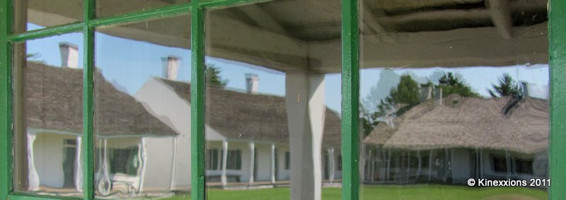
The Officer's Quarters and another building reflected in the old glass windows of another building.


I thought it was interesting that the four buildings housing the married enlisted men and their families were outside the gates of the fort!


One of the other things that I thought was really interesting is that they displayed copies of original documents – some census records, muster rolls, etc. and they have documented the lives of most of the men who served at Fort Wilkins!

This graphic, with reflections abounding, tells the tale of the soldiers stationed at Fort Wilkins. Wouldn't it be neat if one of your ancestors had served there?

In total, two hundred seventy-one enlisted men served at Fort Wilkins between 1844 and 1870. Records for all but ten have been found. What became of these soldiers after they left here?

  • One of every twelve died in the army – half of them from natural causes.
  • One of every ten serving here in the 1840s was a battlefield casualty in the Mexican War.
  • One of every nine enlisted men to serve here left the army by desertion.
  • Less than 4% (one of every twenty-six) re-enlisted.

More photos of Fort Wilkins via Google Images.

Monday, August 15, 2011

Another Indian Lake Sunset

Friday, August 5th - - As I drove “home” to the campground at Indian Lake after spending much of the day at my “private” beach at Pictured Rocks National Lakeshore, the clouds began gathering. Rain was forecast for Saturday and it looked like it was coming sooner than predicted. I made it back to the campground in time for a stroll along the shore of Indian Lake at sunset.


The ducks (there were others not pictured) were enjoying the water at sunset, bathed in the golden glow of the fading light.

Like most everyone else, I generally take sunset pictures with the camera in “landscape” or horizontal orientation. Because the clouds were so dramatic, along with the reflections in the water, I decided to do a series of “portrait” shots or with a vertical orientation... Enjoy!


Sunday, August 14, 2011

Pictured Rocks :: Miners Castle

Friday, August 5th - - It was about a 50-mile drive from the campground at Indian Lake to the western end of the Pictured Rocks National Lakeshore. It was a beautiful day. My intent was to take a 2 ½ hour Boat Cruise along the coast of Lake Superior but I turned right at the intersection instead of left and ended up at the only “pictured rock” that is visible from shore – Miner's Castle.


The view from the overlook was magnificent! The water in the cove was so clear you could see the bottom – a sign stated that the average depth was 25 feet and it dropped off rapidly from the shoreline. If you look closely you can see some people lounging on the rocky shoreline and some were floating in the crystal clear water.


A close-up view of Miner's Castle – some of the people are more visible.


These three swimmers were almost directly below – they are there – in the middle of the photo. Can you see the canoe on the shore? It is to the left of the large clump of leaves on the right. I walked down to the lower overlook but was not impressed. There really wasn't much of a view at all from there.


Then I drove a short distance to the parking lot for Miner's Beach. Nary a spot to park and people parking where they really shouldn't have! So, not to be put off completely, I went back to the intersection and turned the other way to the parking lot for a lakeside trail. Several parking spots were available so I grabbed one of them and headed off. The trail lead to the cove shown above. It was another 1.5 miles to Miner's Beach but I stopped off here for a while. And lingered. There were only half a dozen other people there and some of them left after a while. Soon I was the only one there!


Discarding shoes and socks and rolling up the pants legs, I strolled along the water's edge. The wet sand was like walking in quicksand. It grabbed your feet and held them tight. Then the water washed over the sand and released them. Venturing out a little further into the water there was a layer of smooth rocks along the shore and walking was much easier. Never mind that the pants got wet well above the knees! It felt so good in the 80 degree sunshine!

I lingered there for several hours absorbing the sun's rays and enjoying the cooling breeze. Sorry, Carol, but there will be no photos of the Pictured Rocks from a boat - I never made it to the dock!

Wednesday, August 10, 2011

Indian Lake Sunset

Thursday, August 4th - - For whatever reason (too many trees blocking the view, just not being in the right place, etc.) I haven't viewed a sunset full-on since leaving Indiana on July 12th! Tonight that “nasty” streak came to an end at Indian Lake State Park near Manistique on the Lake Michigan side of the Upper Peninsula.

Clouds. Calm Water. And a Setting Sun. It doesn't get much better than that!


8:45 pm


8:58 pm


9:04 pm


9:14 pm


9:20 pm


9:24 pm

Tuesday, August 09, 2011

Pictured Rocks National Lakeshore

Thursday, August 4th - - Unless you want to travel on back-country dirt roads, the route to Pictured Rocks National Lakeshore takes you south, then west, and then back north to County Highway 58, which follows the shoreline of Lake Superior for a few miles then takes you back inland. The drive reminded me of the route through Canada last August on the Alaska Highway – curves and hills midst a tree-lined road, with nothing in sight except more trees!

One of the first stops within the National Lakeshore is Au Sable Point where there is a very nice, but not very photogenic cascading waterfall. Too much contrast with bright sunshine and heavy shade. If I was into HDR (High Dynamic Range) Photography, this would have been a good place to experiment with it.

A short distance down the road was a place called Log Slide Overlook. A flyer picked up at the waterfall trail said of the Log Slide: “The 1,000 foot trail to the viewing platform from the picnic area is worth the walk. Newspaper accounts tell of logs sent down the dry log chute generating enough friction to cause the chute to catch fire. Today the chute is gone, but the lumberjack stories still linger as you gaze out over the Grand Sable Banks and Dunes.”


A short walk on a very well manicured path leads you to a small sand dune, about 25 feet high. This is the view from the top, overlooking Lake Superior. What you can't see is that beyond that opening is a 500 foot drop to the water's edge!

Perhaps “drop” is a bit dramatic, but a nearby sign states that the distance from the top of the dune to the lakeshore is 500 feet with 200 feet being nearly vertical. It also states that it takes only a few minutes to get to the bottom but can take an hour or more to climb back up!


The view looking to the east toward Grand Marais.


This is the view looking down toward the lakeshore, 500 feet below.


And this is the same view showing some rather energetic and youthful people near the bottom of the dunes. Provides a bit of perspective, doesn't it?

Needless to say (but I'll say it anyway), I did not even attempt this feat. I was pretty sure the old legs would give out on the way down and if they didn't the heart and lungs would get quite a workout on the way back up!

Saturday, August 06, 2011

Upper Tahquamenon Falls

The “showcase” of Tahquamenon Falls is the Upper Falls, which is about four miles upstream from the Lower Falls. It is larger and more dramatic – it has a drop of 50 feet and is more than 200 feet wide.


But first, I had to slip this in...A “fact shack” has a nice display of information about the falls and an impressive display recognizing the comeback of the gray wolf. I was hypnotized by the stare of this fellow – stuffed and amazingly life-like.

Paved trails from the parking lot lead to the Upper Falls, so it is an easy walk. Several viewing areas along the way provide a good look at the falls.


At the end of the trail is a staircase with 94 (or maybe it was 84, whatever, it was a lot) steps that have to be taken down (and back up). But it's worth the effort to get a close-up view of the magnificent falls.


Returning to the top of the steps and following the path back, I noticed a second pathway that continued south and down to the gorge. At the end I was faced with another staircase - this one of 118 steps - that went down to the river. I hoped that the view would be worth the effort – the temperature was 80 degrees and the humidity was probably 98% - it had rained in the morning.

The views did indeed provide a different perspective of the falls...


It was awesome, in spite of the gloomy, gray, rainy day. Lucky for me, on this day the rain stopped mid-day. Photos were taken on Tuesday August 2nd.

Friday, August 05, 2011

Lower Tahquamenon Falls

Tahquamenon Falls are a little over an hour west of Sault Ste. Marie and were among the “must see” things that my friend Carol said that I “had” to see while in the UP! According to Carol, the pronunciation of Tahquamenon is “something like” Taaaaa quaaaaaa men on. I'll take her word for it!

There are actually two areas here, the Lower Falls and the Upper Falls. The Lower Falls are a series of smaller waterfalls coming down on either side of an Island.


The two falls shown here are on the east side of the Island.


Rowboats were available for rental to take out to the Island where there is a boardwalk that goes around the Island and affords different views of the falls. As much as I would have liked to, I'm not very adept at rowing a boat so didn't attempt this little excursion. The falls in the background are the same ones in the first picture.


This is the last of a series of three smaller falls that are on the west side of the Island. A boardwalk leads you along the river to several viewing platforms.


An interesting sign along the way - Prayer of the Woods.


Another sign – showing the layout of the river and island and warning of the dangers of the falls.


From one of the viewing platforms, looking back at where the first few pictures were taken.


Fast flowing water. The brown color is caused from tannin brought in from the streams that flow into the river.


The uppermost of the Lower Falls. Visitors to the Island wade out into the river.


And finally, a closeup of the flowing waters.

Thursday, August 04, 2011

Into the U.P.


Crossing the Mackinac Bridge into the Upper Peninsula of Michigan.
July 31, 2011

The first stop was at Brimley State Park, about 15 miles west of Sault Ste. Marie, on the shores of the St. Mary's River. Several pleasant days were spent in the area. Blue skies and sunshine were abundant. Daytime temperatures in the mid-80s with lows in the 60s overnight. Very nice!

Of course I visited the Locks at Sault Ste. Marie. A very large freighter had just entered the locks from the higher Lake Superior side. It took quite a while to get it lowered so it could eventually make its way to Lake Erie and eastward. Movement was imperceptible. Only when you looked away for a few minutes then looked back at the ship could you tell it was sitting lower beneath the top of the locks. Eventually the gates of the locks opened and the ship was on its way. I overheard the Park Ranger (Sault Locks is a National Historical Park) telling someone that the ship that went through was 105 feet wide while the locks were 110 feet wide. A rather tight fit overall.


A few minutes later, a small tourist boat came through. Entering from the east side it had to be raised in order to exit on the west side and into Lake Superior.


The top of the boat is below the top of the locks.


Twelve minutes later, the little boat was on its way. It didn't take nearly as long to raise this little boat as it took to lower the large freighter.

A very nice visitor center has displays on the history of the building of the locks as well as a very informative 20-minute movie.